People everywhere have always walked, "veining the earth with paths visible and invisible, symmetrical or meandering," as author Thomas Clark put it. Long before European contact, the indigenous people had created an elaborate system of foot paths crisscrossing eastern North America, some following tracks worn by buffalo and other megafauna through eons of use prior to the arrival of humans over 13,000 years ago. These ancient trails were often used for travel over quite long distances, whether in trade or in war or simply in maintaining contact with distant family members. [1]
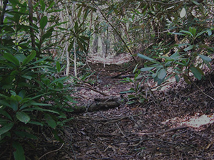
Figure 1. Some of the most important foot paths were much like this portion of the Unicoi Trail preserved near Conasauga Creek in the Cherokee National Forest. (Photo by Dirt e Deeds, 2011, CC BY-SA 3.0. Wikipedia Creative Commons) |

Figure 2. Less traveled trails might have resembled this modern foot path near Arabia Mountain in southern DeKalb County (Photo by Tommy H Jones, 2017) |
The early trails avoided rough or swampy terrain and dense undergrowth such as laurel thickets and cane brakes for the same reasons we do, ease of travel and protection of footwear and garments. These trails often followed ridgelines and other high ground, which typically offered firmer footing and fewer obstacles to travel, and they were usually less than two feet wide as people wound their way single-file through the area's hilly and heavily wooded landscape. With the introduction of horses among the southeastern Indians in the 1690s, some trails were widened to four, five, or even six feet in width.
The routes of trails were often dictated by the presence of convenient crossings of the area's numerous rivers and streams. One of the most notable of those crossings near modern-day Atlanta was Shallow Ford on the Chattahoochee River, eighteen miles north of downtown but now drowned by Bull Sluice Lake. There were other river fords downstream, including near the mouth of Peachtree Creek and, ten miles downstream from there, at Buzzards Roost. Rock Bridge on the DeKalb-Rockdale County line was a natural bridge of sorts over the Yellow River and an important landmark for early people as well. Other natural features were also destinations, including Soapstone Ridge, six miles southeast of downtown, where steatite was being quarried, worked, and widely traded as early as 1500 BCE, and Stone Mountain, where the trail up its western slope has been in use for thousands of years.
The fall line on the Savannah River, a few miles upstream from present-day Augusta, is the site of some of the earliest, more or less permanent, human occupation yet documented in the southern Piedmont, beginning as early as four thousand years ago. A series of important, long-distance trails radiated from those falls, to the west forking and forking again into paths that, during the historic period, led to the Cherokee towns in northern Georgia and Tennessee and to the Creek towns on the lower Chattahoochee, Tallapoosa, and Coosa Rivers.
Most trails of these trails were not so much a single entity as they were a braid of alternative routes, some of which might, for example, provide a shorter route but be impassable in wet weather, others longer but more reliable. In addition trails often went by different names, depending on one's destination, similar to the nomenclature used for area roads. The same thoroughfare is called, for example, Decatur Street east of Five Points and Marietta Street to the west. As the noted ethnographer John R. Swanton (1873–1958) cautioned, "there is, and always must be, considerable artificiality in the determination of what constitutes a trail, and where a trail begins and ends." In addition, he noted that it is "largely a matter of convention which of two branches of a trail should be considered as the fork and which as the main trail." [2]
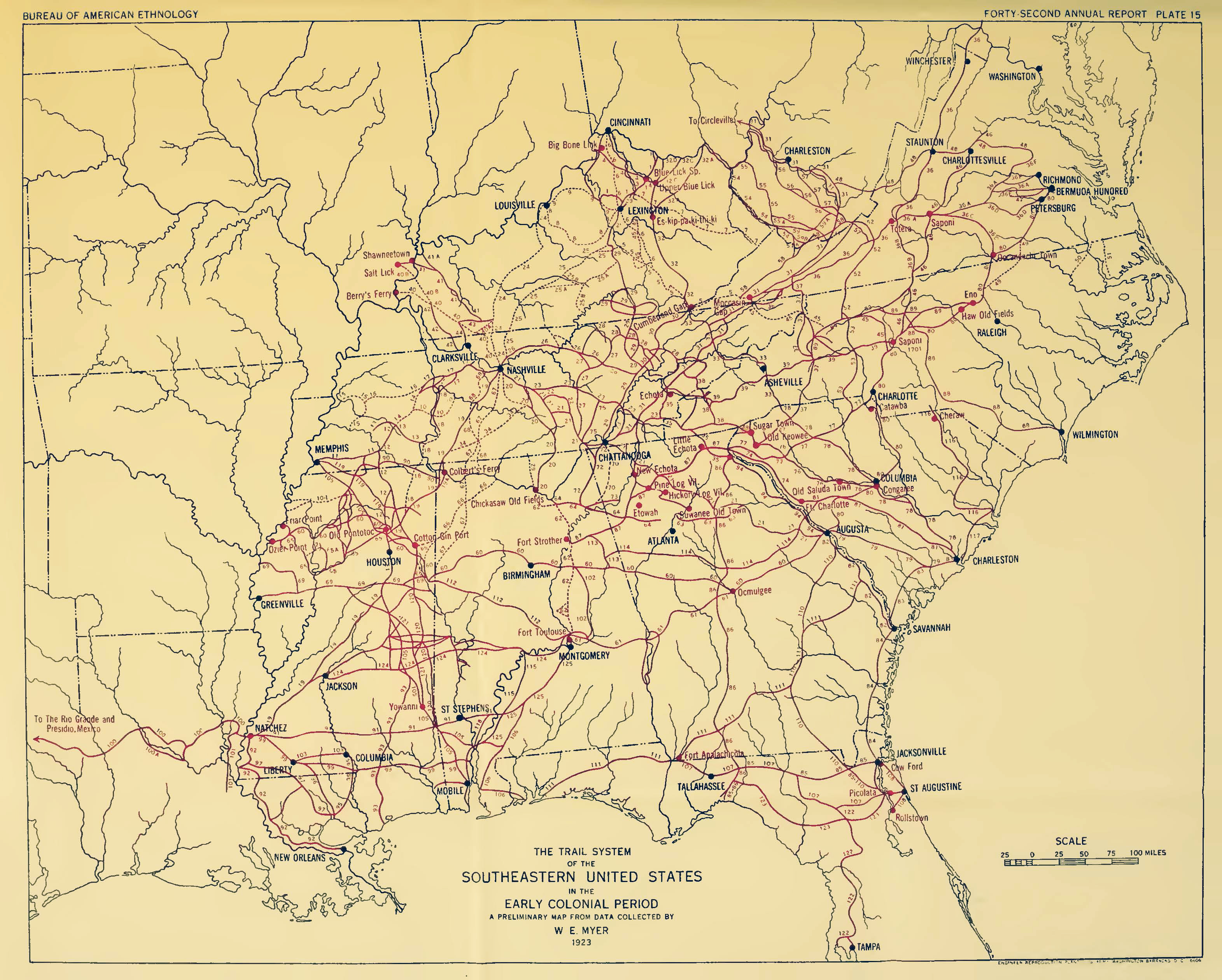
Figure 3. W. E. Myers's map of major Indian trails across the southeastern United States. ("Indian Trails of the Southeast," Forty-second Annual Report of the Bureau of American Ethnology: 747) |
Regional Trails
The Hightower Trail was one of the best known of the ancient, long-distance trails near what is now the City of Atlanta. It diverged from the Upper Creek Trading Path just west of the Oconee River in eastern Morgan County and led in a northwesterly direction via Rock Bridge to Shallow Ford. From there it continued to the great convergence of trails in and around Etowah near Cartersville, the site of a magnificent Mississippian mound complex. The exact route of most ancient trails is often difficult to determine, but the Hightower Trail was used in the Treaty with the Creeks in 1818 to define part of Georgia's new western border. In 1821 when another treaty shifted the border even further to the west, the trail became the line between Gwinnett and DeKalb counties and part of it remains so today. That original boundary, and so the location of Shallow Ford, can still be readily identified where the line between the Sixth and Seventeenth Districts in north Fulton County meets the river. A segment of the route also survives west of Dunwoody Place and is still called Hightower Trail. [3]
Just west of Rock Bridge, another long-distance trail diverged from the Hightower Trail and led in a westerly direction. Often called the Sand Town Trail, it crossed the Chattahoochee River at Buzzards Roost, an island just downstream from the mouth of Utoy Creek, about nine miles west of downtown. From there, it continued on to the towns of the Upper Creek in Alabama. The main route of the Sand Town Trail appears to have followed what is now Rockbridge Road to Decatur and then MARTA's East Line to Five Points in downtown Atlanta and southwest along the high ground between Utoy and Camp Creeks to Buzzards Roost, where the river could be forded. Part of the route of the Sand Town Trail is approximated in the block of modern Trinity Avenue west of Forsyth Street and Peters Street in downtown Atlanta and Cascade Road in southwest Atlanta. The Sandtown Road in southwest Atlanta is likely not a relic of the trail from Rock Bridge but rather of a spur from Flat Shoals or other points to the southeast.[4]
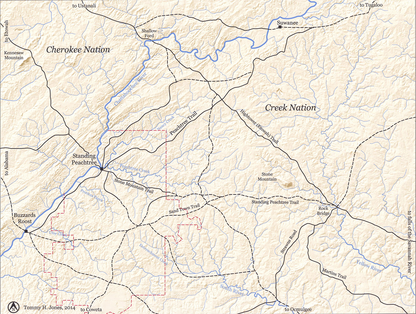
Figure 4. USGS map annotated to delineate general routes of Indian paths and trails that existed in the eighteenth and early nineteenth centuries. Red lines indicate the corporate limits of the City of Atlanta. Solid lines indicate the routes of trails delineated on the district plats of survey and/or the plats of individual land lots in 1821. Black dashed lines indicate the approximate route of other important trails that are documented elsewhere in the historical record. (Annotations by Tommy H Jones, 2014.) |
In what is now downtown Decatur, the Sand Town Trail crossed an important north-south trail connecting Flat Shoals and Indian Springs to Shallow Ford, its route still traced in parts of Candler, Clairmont, and Shallowford Roads. A trail to Standing Peachtree left the Shallowford Trail a mile or so north of the Sand Town Trail, trending in a westerly direction along a route approximated by today's N. Decatur Road as it runs through Druid Hills, Rock Springs Road through Morningside, and part of Montgomery Ferry Road across Piedmont Heights into Sherwood Forest. The route westward from there is lost until picked up again with Collier Road through Collier Hills and on to DeFoors Ferry Road and the site of Standing Peachtree.
Just east of what is now Briarcliff Road, a trail diverged to the south. Designated "Sand Town Path" on the State surveys, it is shown looping through Morningside and crossing the southeast side of Piedmont Park. Delineation of the trail ended near what is now the intersection of Eighth Street and Argonne Avenue, which is at the southern boundary of the Seventeenth District. The trail certainly continued in a southerly direction from there, but it was not delineated in the surveys for the adjoining Fourteenth District. Considering the topography and the route of other trails recorded in the 1821 surveys (of which more below), it may be that the southern end of this segment of the "Sand Town Path" was also the genesis of what is now Peachtree Street in Downtown Atlanta. [5]
Finally there was what has been called the Peachtree Trail, which may have been part of a series of trails that followed the high ground that parallels the the Chattahoochee River from Tugaloo in present-day Stephens County and the other Lower Cherokee towns in northeastern Georgia and western South Carolina. Passing Suwanee, site of a Shawnee town that had been abandoned before 1780, the Peachtree Trail continued southwesterly before branching just west of Duluth, with one branch following the high ground on the north side of Nancy Creek, the other following the ridge on the south, and Standing Peachtree being the destination of both.
Standing Peachtree
The most important of the few Indian settlements around what is now metropolitan Atlanta was Standing Peachtree, located on the Chattahoochee River near the mouth of Peachtree Creek, six miles northwest of downtown, where the river could be forded at least part of the year. The archaeological record suggests that the site was first inhabited during the Mississippian period, perhaps a thousand years ago. Clusters of houses amid fields of corn, beans, and squash were scattered on both sides of the river for several miles, but Standing Peachtree was the primary village. The State's land surveys in 1821 show a convergence of trails around Land Lot 231, which encompasses the mouth of Peachtree Creek and the heart of Standing Peachtree. Just west of what is now Ridgewood Road, near the center of the land lot and encircled today by Coronet Way, was a large earthen mound, and there was at least one more mound across the river. Still others could be found further down the river.
The Creek called the place Pakanahuili, with huili the Muscogee word for "standing," an adjective often found in early place names such as Standing Boy Creek near Columbus and Standing Rock near Senoia. As for the tree, some have argued that it was not a peach tree at all, but a “pitch tree,” a great pine which grew on the hill on the north side of the creek and which the Indians blazed for its resin, or pitch. [6]
The most widely accepted explanation for the name is contained in an 1897 newspaper interview with noted Atlanta pioneer George Washington Collier (1814–1903). He had come to the area with his family just after the War of 1812 and delivered mail from the post office at Standing Peachtree to Allatoona in what is now southeastern Bartow County in the early 1830s. He recalled that "[t]here was a great huge mound of earth heaped up there—big as this house, maybe bigger—and right on top of it grew a big peach tree." That, Collier said, was the origin of the name. [7]
Peaches were introduced into the New World by the Spaniards in the late sixteenth century and were often cultivated by the Indians; the great naturalist William Bartram noted "old Peach and Plumb orchards" in his travels through the upper Savannah River valley in the 1770s. Mounds at Standing Peachtree and elsewhere in the vicinity of Atlanta have been obliterated, some within the last fifty years, but their presence around the mouth of Peachtree Creek is documented in the historical record. The most prominent of the mounds was destroyed when the city built the pumping station for its waterworks in 1893, but it nevertheless may be true that a solitary peach tree, growing on top of an ancient Mississippian mound, gave rise to the place's name, "Standing Peach Tree." [8]
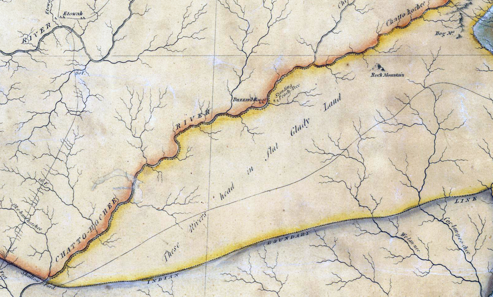
Figure 5. Detail from Eleazar Early's map of Georgia, published in 1818 and the first to depict the most-recent Creek land cession. It is also the earliest state map to show Standing Peachtree, but the map is very distorted, with Shallow Ford (lower left) far south of its actual location and Buzzard Roost and Standing Peachtree (just above center) on opposite banks of the Chattahoochee River upstream from Shallow Ford when they were themselves miles apart and downstream from the ford. ( Historic Maps, Surveyor General, RG 3-8-65, Georgia Archives) |
The place first appears in the historical record as "the standing Peach Tree” in a letter dated 27 May 1782 from John Martin, head of the Georgia militia, to Gen. Andrew Pickens, who led the South Carolina militia. Having just returned from a meeting with friendly Muscogee chiefs, Martin pleaded for assistance against the faction of the Creek Nation that was allied with the British in the ongoing American war for independence. He warned the general that "Mr. McIntosh with a strong party of Cowetas etc. were to rendezvous at the Standing Peach Tree the 26th of this month and they were afterwards to meet at the Big Shoal where to fall on the Okonnys on our Frontiers, therefore we have every reason to expect they will be in upon our back settlements in about 8 or 10 days at the farthest." The outcome of that particular threat is unclear, but Georgia's conflict with the Creek would continue for over forty years. [9]
In August 1790, representatives of the Creek Nation signed a treaty with United States commissioners that, in addition to guaranteeing "perpetual peace and friendship," fixed Georgia's western frontier at the Oconee River, sixty or seventy miles east of today's Atlanta. It did not remain there long. A treaty in 1805 pushed the boundary thirty or forty miles further west to the Ocmulgee and Alcovy Rivers and also provided that "the government of the United States shall forever hereafter have a right to a horse path, through the Creek country, from the Ocmulgee to the Mobile." Ostensibly a post road, the Creek were irate to discover that simple foot logs over the creeks, as stipulated in the treaty, had morphed into bridges and the horse path itself into a wagon road, all part and parcel of Gen. Andrew Jackson's strategy to destroy the Creek confederacy. With these roads, one historian noted, "the palimpsest was scored again as the trading paths, post roads, and traveler's routes were rutted with commissary wagons and heavy weaponry."[10]
In June 1812 war broke out between the United States and Great Britain, and at the same time the Creek were descending into civil war. The so-called Red Stick faction of the Creek was more than ready to fight on the side of the British, and their raids on the Georgia and Alabama frontier culminated in a dreadful massacre of white settlers, militia, and their Indian allies at Fort Mims in Alabama on 30 August 1813. By October, the federal agent for the Creek reported to the commander of the Georgia Militia that the Red Sticks were threatening to destroy all of the Lower Creek towns and to "then take the post road, enter Georgia, ravage all before us out round Hog Mountain," which was then the westernmost point on the Georgia frontier. The state militia's fort at Hog Mountain was soon rebuilt and its garrison strengthened as state, federal, and Indian forces combined to put down the Red Sticks.
Peachtree Road
The logistics of supplying the main military garrison at Fort Mitchell overland proved daunting, and a plan was devised to build a palisaded, log fort on the Chattahoochee River at Standing Peachtree. Below that point, the river was navigable by shallow-draft flatboat, which the military intended to use to supply its garrison at Fort Mitchell, a hundred miles to the southwest. In early January 1814, Maj. Thomas Bourke of the Army Quartermaster Corps blazed a road between the two forts, reporting to his superior in a letter dated 11 January 1814 that he found eighteen miles of the proposed forty-mile route "had been made use of by Waggons already." [11]
The Army hired local contractors—Robert Young (1760-1851), Isham Williams (1776–1852), and William Nesbit (1789-1863)—who in turn engaged crews of men to actually clear the remainder of the road. It is thought that the new road incorporated ancient trails, but precisely where the route might have deviated from the earlier trails remains uncertain. In some places the surveyors are likely to have identified a new route better suited for a wagon road as they worked their way to the southwest along the high ground between Peachtree and Nancy Creeks to Standing Peachtree. By the spring of 1814, the road was more or less complete.
Designated on early maps "the road to Standing Peach Tree," it soon became "the Peach Tree Road," contracting to "Peachtree Road" by the 1860s. Construction of the Air Line Railroad in the 1870s and the interstate highways a hundred years later have altered the road's route in places but much of it can still be traced in a series of modern thoroughfares running through landscapes rural, suburban, and intensely urban.
The War Department also extended a "river road" from Standing Peachtree south to Sand Town. Like the Peachtree Road and other similar military roads in Georgia and Alabama, it facilitated the United States' slow-motion invasion of the Creek Nation. Before 1821, the Peachtree and River Roads appear to have been the only wagon roads in what became the City of Atlanta, but there were soon others.
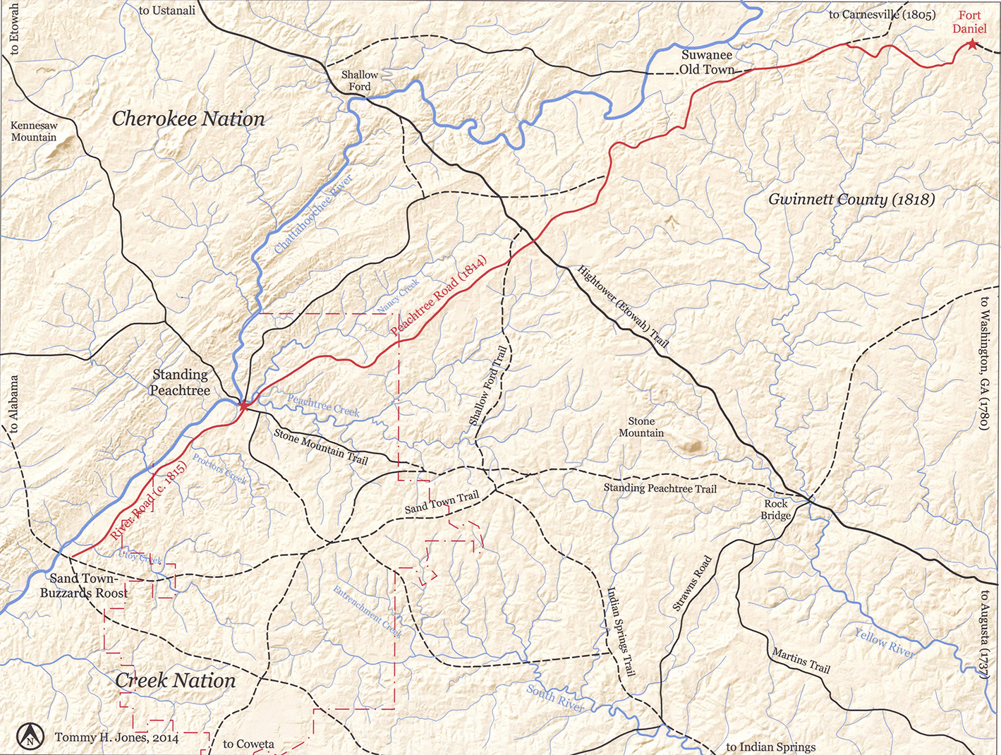
Figure 6. USGS map annotated to highlight the routes of Peachtree and River Roads as they were delineated on the district plats of survey in 1821. The solid lines denote significant trails that are shown on the plats of survey and/or individual land-lot surveys; the dashed lines are trails documented in the historical record but not in those surveys. (Annotations by Tommy H Jones, 2014.) |
![]()
Notes
1. Thomas Clark quoted in Robert Macfarlane, The Old Ways: A Journey on Foot (New York: Penguin Books, 2012), 13. Louis DeVorsey, "Indian Trails," New Georgia Encyclopedia, accessed 5 April 2014. On the ubiquity and character of early trails, see William Edward Meyer, "Indian Trails of the Southeast," Forty-second Annual Report of the Bureau of American Ethnology to the Secretary of the Smithsonian, 1924–1925 (Washington, D.C.: United States Government Printing Office, 1928), 739, 743.
2. John R. Swanton, "Preface" to William Moyer, "Indian Trails of the Southeast," 42nd Annual Report of Bureau of American Ethnology (1924–1925), 731.
3. John Goff, "The Hightower Trail," The Collections of the DeKalb Historical Society 1:2–4 (Decatur: Ga, 1951).
4. . John Goff, "The Sandtown Trail,” The Atlanta Historical Bulletin 11, no. 4 (December 1966), argues that "Sand Town" originally referred to a large Creek town in Alabama. After 1814, some of its inhabitants moved east and settled the eponymous area near the prehistoric settlement of Buzzard's Roost in what is now south Fulton County. Also see Marion R. Hemperly, Historic Indian Trails of Georgia (Atlanta, GA: Garden Club of Georgia, 1989), 30–31.
5. . The plat of survey for the Seventeenth District and the land lot surveys name the "Sand Town Path." State of Georgia, records of the State Surveyor General, Record Group 003-03-024, District Surveys, 1821, Georgia Archives.
6.. John Goff, Placenames of Georgia (Athens: University of Georgia Press, 1974, paperback edition 2007), 171–2.
7.Collier quoted by Robert Adamson, "'The Oldest Inhabitant'—Came Here a Full Generation before Atlanta was Started—An Afternoon with the Pioneer at Home," Atlanta Constitution, 25 April 1897, microfilm at Atlanta-Fulton County Library.
8.` The history of Standing Peachtree has long been an object of study for local historians. See Eugene M. Mitchell, 'The Story of 'The Standing Peachtree'," Atlanta Historical Bulletin 1, no. 2 (January 1928): 8-19; Wilbur G. Kurtz, "Standing Peachtree," Early Georgia 1, no. 2 (Fall 1950): 30–42; Franklin Garrett, Atlanta and Environs, Vol. 1 (Athens: University of Georgia Press, 1954, facsimile reprint 1969, 1982 printing), 8. Also N. Finegan and W. E. Merrill, Atlanta & vicinity: compiled from state map and information (Chattanooga, Tenn. : United States Army Corps of Topographical Engineers, 1864) notes a shoal in the river between the small island and the mouth of Peachtree Creek and that it was "fordable in summer."Mitchell notes the mound on the site of the waterworks pumping station on the south side of the creek. Franklin Garrett, Atlanta and Environs, Vol. 1 (University of Georgia Press, 1954, facsimile reprint 1969), 8, notes the presence of another mound on the west side of the river. A mound is thought to have been destroyed when Six Flags Over Georgia was built in the mid-1960s. Dylan Woodliff, "Revisiting Anneewakee Creek (9DO2)," Society for Georgia Archaeology, accessed 26 March 2015, discusses a recently destroyed mound on the west side of the river opposite today's Campbellton.
9. Quotation in Kurtz, "Standing Peachtree," 31.
10. Angela Pulley Hudson, Creek Paths and Federal Roads: Indians, Settlers, and Slaves and the Making of the American South (Chapel Hill, NC: University of North Carolina Press, 2010), 113.
11. James D'Angelo, Ph.D., R.P.A., "A New Take on an Old Story: Fort Daniel, Fort Peachtree, and the Road that Connected Them," Gwinnett Historical Society Heritage 43, No. 1 (Spring 2014), 6-8. D'Angelo has directed archaeological research on the site of Fort Daniel and has also done extensive archival research in state records to document the origins of the forts and the road between them. His conclusions challenge some of the traditional accounts of those early events. See "The Fort Daniel Foundation, Inc." accessed online at <http://www.thefortdanielfoundation .org/History.htm, 6 June 2014>. For the traditional story, see Franklin Garrett, Atlanta and Environs, Vol. 1, 13-16; and James C. Flanagan, History of Gwinnett County Georgia 1818–1943. Vol. 1. (Lawrenceville, GA: 1943, facsimile reprint by Alice Flanagan, 1995), 16–18.
|
continue to |